11 min read / Bikal Shrestha & TrekGuard Team
Walking Into Langtang via Helambu and Gosaikunda: The Real Route for Autumn 2026
A 10-day version of the Sundarijal-to-Langtang walk-in is circulating on social media. It is missing four days and a 4,610 m pass. Here is the honest 15-day route, the acclimatization maths, and the road advisory that still governs the exit.
Photo: Hari Paudyel / CC BY-SA 4.0
Quick Summary
TL;DR - Key Takeaways
- With the Betrawati-Syabrubesi road corridor still broken after the 26 August 2026 Rasuwa flood, trekkers are sharing a walk-in route to Langtang that starts at Sundarijal on the Kathmandu valley rim instead of driving to a trailhead.
- The route itself is real and long-established. The widely shared 10-day version is not: it compresses Kutumsang to Thulo Syabru into a single day, when that leg is four walking days over Laurebina La at 4,610 m - the highest point of the entire trek.
- Walked honestly this is a 15-day, strenuous, high-pass trek, not a 10-day valley walk. Northbound over Laurebina La is the harder direction for acclimatization, gaining roughly 1,800 m into thin air if you push it.
- Access has partly improved: light 4WD vehicles reached Dhunche again from 29 August 2026 via the Bogatitar-Kalikasthan alignment. Travel north of Dhunche - Thulo Syabru, Syabrubesi, Langtang trailheads - is still under advisory. Confirm status before you commit.
The 10-Day Itinerary Going Around Is Missing Four Days and a 4,610 m Pass
A day-by-day plan circulating on social media presents the Langtang walk-in as a 10-day trip: Kathmandu to Sundarijal to Chisapani on day one, Chisapani to Kutumsang on day two, and then - on day three - Kutumsang to Thulo Syabru.
That third day does not exist. Kutumsang (2,470 m) and Thulo Syabru (2,260 m) sit on opposite sides of the Laurebina range. Getting between them on foot means Tharepati, Ghopte, Phedi, the Laurebina La pass at 4,610 m, Gosaikunda, Cholangpati and Sing Gompa. That is four walking days for a well-paced trekker, five if you take the acclimatization day the altitude profile asks for.
The omission matters more than a scheduling error usually would, because the deleted days contain the entire high-altitude section of the trek. A trekker following the 10-day plan would arrive at Kutumsang believing the hard part was behind them, and instead find a 2,100 m climb to a pass higher than Everest Base Camp's approach villages.
The rest of the shared itinerary is sound. Thulo Syabru to Lama Hotel, Langtang Village, Kyanjin Gompa, the Kyanjin Ri or Tserko Ri viewpoint day, and the walk back out are the standard upper Langtang stages, and they match our own route data. It is the middle that is wrong.
Photo: Hari Paudyel / CC BY-SA 4.0
Ground Status: What Is Open in Rasuwa as of 5 September 2026
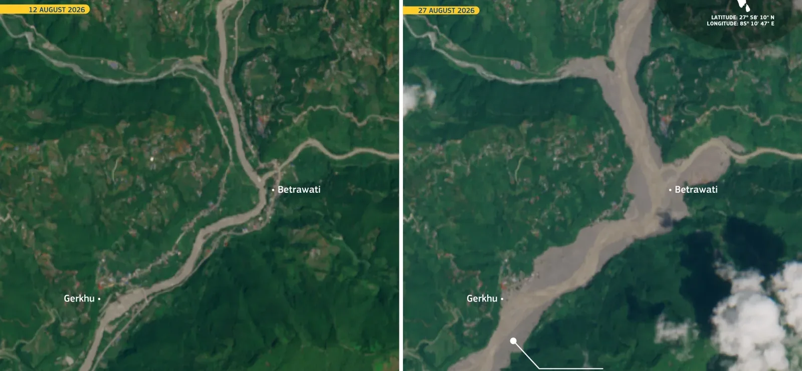
The 26 August 2026 flood in the Bhote Koshi and Trishuli corridors destroyed roughly 40 km of the Betrawati-Rasuwagadhi road along with dozens of bridges. That is the road tourist jeeps used to reach Syabrubesi, and it is why the normal Langtang approach stopped working.
Access has since partly recovered, and the picture is now more specific than "Langtang is closed". Radio Nepal reported on 29 August 2026 that light four-wheel-drive vehicles reached Dhunche again on the Bogatitar-Kalikasthan alignment, bypassing the worst of the destroyed section. Dhunche, the Rasuwa district headquarters, is therefore reachable from Kathmandu again in small vehicles, subject to weather.
North of Dhunche is a different matter. The Department of Roads reports only partial opening on the Galchhi-Trishuli-Syabrubesi-Rasuwagadhi route, and reliable through access beyond Dhunche to Syabrubesi, Timure and the Langtang trailheads has not been confirmed. The US Embassy advisory is explicit: do not travel north of Dhunche until authorities confirm through access and the flood threat subsides.
This is the detail that undercuts the framing of the walk-in as a way to sidestep the problem. The route does avoid the destroyed Betrawati-Mailung-Syabrubesi section, which is genuine. But it exits through Thulo Syabru and Dhunche, and Thulo Syabru is north of Dhunche - inside the advisory area. You are not walking around the closure so much as walking into the far side of it.
Conditions in this corridor are changing week to week. Treat every figure in this article as needing confirmation against the road status on the day you travel, not as a standing fact.
Photo: pnepalensis / CC BY-SA 4.0
The Honest Itinerary: 15 Days, Not 10
This is the route walked at a pace the altitude profile supports, starting from the Kathmandu valley rim and finishing back at Dhunche. Sleeping altitudes are what matter for acclimatization, so those are the numbers in the table - not the high point you touch during the day.
Two stages deserve attention. Day 5 is deliberately short: Ghopte to Phedi is only about 2.5 hours, and the temptation is to push straight on over the pass. Do not. Day 6 already gains 640 m of sleeping altitude and crosses 4,610 m to get there, which is above the usual 500 m per day guideline on its own.
Day 7 at Gosaikunda is an acclimatization day, not padding. If you cut it, the pass day and the descent stack on top of an altitude you reached fast, and Gosaikunda is a poor place to develop symptoms - the nearest meaningful descent is several hours in either direction.
A 13-day version exists and is walked regularly by fit, already-acclimatized trekkers who merge Ghopte to Gosaikunda into one eight-hour day over the pass and skip the rest day. That is a legitimate choice for the right person. It is not the version to hand to someone who flew into Kathmandu five days ago.
| Day | Stage | Sleeping altitude | Notes |
|---|---|---|---|
| 1 | Kathmandu to Sundarijal, walk to Chisapani | 2,140 m | Shivapuri Nagarjun National Park entry gate at Sundarijal |
| 2 | Chisapani to Kutumsang | 2,470 m | Ridge walking, long but easy |
| 3 | Kutumsang to Tharepati | 3,640 m | First real climb, +1,170 m |
| 4 | Tharepati to Ghopte | 3,440 m | Descent through forest, about 6 hours |
| 5 | Ghopte to Phedi | 3,740 m | Short on purpose - about 2.5 hours |
| 6 | Phedi over Laurebina La (4,610 m) to Gosaikunda | 4,380 m | The crux day. Steep stone staircases to the pass |
| 7 | Gosaikunda | 4,380 m | Acclimatization day - do not skip |
| 8 | Gosaikunda to Sing Gompa | 3,330 m | Via Cholangpati, mostly descent |
| 9 | Sing Gompa to Thulo Syabru | 2,260 m | Long forest descent |
| 10 | Thulo Syabru to Lama Hotel | 2,470 m | Joins the classic Langtang valley trail |
| 11 | Lama Hotel to Langtang Village | 3,430 m | Through the 2015 landslide site |
| 12 | Langtang Village to Kyanjin Gompa | 3,870 m | Short day, arrive early |
| 13 | Kyanjin Ri (4,773 m) or Tserko Ri (4,984 m) | 3,870 m | Climb high, sleep low |
| 14 | Kyanjin Gompa to Lama Hotel | 2,470 m | Long descent day |
| 15 | Lama Hotel to Thulo Syabru to Dhunche, drive to Kathmandu | 1,960 m | Only if road status north of Dhunche allows |
Laurebina La Is the Whole Problem
Direction matters here more than on most Nepal routes. Walked northbound from Kutumsang, as the shared itinerary does, you approach Laurebina La from the low side and climb roughly 1,800 m into the pass if you run the stages together. Walked southbound from Thulo Syabru, you arrive at the pass having already slept at Sing Gompa and Gosaikunda, acclimatized by the climb itself.
In other words: the direction being shared is the harder one for altitude illness, and the itinerary being shared removes the days that make it survivable. Those two errors compound rather than cancel.
If you walk this route, the acclimatization rules are the ordinary ones and they are not negotiable at 4,610 m. Keep sleeping-altitude gain near 500 m per day above 3,000 m, take the Gosaikunda rest day, and treat a headache that appears at Phedi or Gosaikunda as altitude illness until proven otherwise. Our Lake Louise AMS self-check mirrors the scoring the app uses, and the acclimatization planner will show you the gain rate for any schedule you are considering.
The descent options from the pass are genuinely limited, which is what makes this section unforgiving. From Gosaikunda you are several hours from meaningfully lower ground in either direction, and Phedi's lodges are seasonal. Plan to arrive at the pass early in the day with the weather settled, and turn around rather than commit if it is not.
Permits: One More Than the Standard Langtang Trek
Starting at Sundarijal adds a permit that a normal Syabrubesi-based Langtang trek does not need. The trail out of Sundarijal enters Shivapuri Nagarjun National Park immediately, and entry is charged at the gate: NPR 1,000 for foreign nationals, NPR 600 for SAARC citizens, NPR 100 for Nepali citizens. Trekkers who plan only for the Langtang permit are caught out at the first checkpoint of the trip.
Beyond that the permit set is the usual one for the region: the Langtang National Park entry permit, which covers Gosaikunda and the upper valley alike, plus a TIMS card. Both are issued at the Nepal Tourism Board in Kathmandu, and the park permit can also be bought at the park entry point.
You can check the current fee estimate for the Langtang permits on our permit checker, and the full picture in the Nepal trekking permits guide. Fees are set in rupees and revised by notice, so confirm before you pay.
No restricted-area permit and no mandatory guide requirement applies to this route. That said, the walk-in crosses a high pass in a corridor where rescue logistics are currently degraded, which is a stronger argument for walking it with a guide than any permit rule would be.
When This Route Makes Sense, and When It Does Not
It makes sense if you have 15 days, prior high-altitude experience, and you specifically want Gosaikunda and Langtang in one trip. That combination has always been a fine trek in its own right, entirely independent of the road situation - the lakes are a genuine destination, not a detour.
It does not make sense as a substitute for the 7-8 day Langtang valley trek you originally booked. Different trip, different difficulty class, roughly double the duration, and a 4,610 m pass in the middle. If your reason for choosing Langtang was that it was short and low, this is not the replacement - our six Langtang alternatives covers routes that actually match that brief.
And it does not make sense at all while the exit is unresolved. Walking 9 days to Thulo Syabru on the assumption that you can get out through Dhunche, and finding you cannot, is a bad position to be in with limited teahouse capacity and a degraded road behind you. Check the trailhead road conditions page and confirm locally before committing to the crossing.
If you do go, carry the route offline. Connectivity through Shivapuri, Ghopte and the pass is patchy at best, and the sections where the trail braids through forest above Ghopte are exactly where a downloaded track earns its keep.
Photo: Rsh2020 / CC BY-SA 4.0
Frequently Asked Questions
Can you really walk from Kathmandu to Langtang in 10 days?
No. The 10-day itinerary being shared collapses Kutumsang to Thulo Syabru into one day, when that leg takes four to five walking days and crosses Laurebina La at 4,610 m via Tharepati, Ghopte, Phedi, Gosaikunda and Sing Gompa. Walked at a pace the altitude allows, Sundarijal to Kyanjin Gompa and back out to Dhunche is about 15 days. A 13-day version is realistic for fit, already-acclimatized trekkers who merge the pass day and skip the Gosaikunda rest day.
How high is Laurebina La and where does it sit on this route?
Laurebina La, also written Lauribina or Gosaikunda Pass, is 4,610 m and is the highest point of the whole walk-in - higher than Kyanjin Gompa (3,870 m) and higher than anything on the standard Langtang valley trek except the optional Tserko Ri viewpoint (4,984 m). It sits between Phedi and the Gosaikunda lakes, roughly two-thirds of the way through the crossing from the Helambu side.
Is the road to Dhunche open, and can I exit that way?
Light four-wheel-drive access to Dhunche from Kathmandu resumed on 29 August 2026 via the Bogatitar-Kalikasthan alignment. However, reliable through access north of Dhunche - Thulo Syabru, Syabrubesi, Timure and the Langtang trailheads - has not been confirmed, and travel advisories currently say not to go north of Dhunche until authorities confirm access. Since this route exits through Thulo Syabru, verify the current status before you start walking, not after.
Which permits do I need for the Sundarijal walk-in to Langtang?
Three things rather than the usual two. Shivapuri Nagarjun National Park entry, paid at the Sundarijal gate (NPR 1,000 for foreign nationals, NPR 600 SAARC, NPR 100 Nepali), plus the Langtang National Park entry permit and a TIMS card. The Shivapuri permit is the one trekkers forget, because a standard Langtang trek starting at Syabrubesi never needs it.
Is the Helambu direction harder for altitude sickness than starting from Thulo Syabru?
Yes. Approaching Laurebina La northbound from Kutumsang means climbing to the pass from the low side, gaining roughly 1,800 m if the stages are run together, with limited acclimatization behind you. Going the other way - Thulo Syabru, Sing Gompa, Gosaikunda, then the pass - you sleep progressively higher before crossing. If you have a choice and no fixed reason to walk northbound, the southbound direction is the kinder one.